New chapter: I'm starting as CTO & Co-Founder of Resilens
I am diving back into the world of sustainability tackling the pressing challenges of climate change. Together with a few long-time friends I co-founded a small company called Resilens


I am diving back into the world of sustainability tackling the pressing challenges of climate change. Together with a few long-time friends I co-founded a small company called Resilens
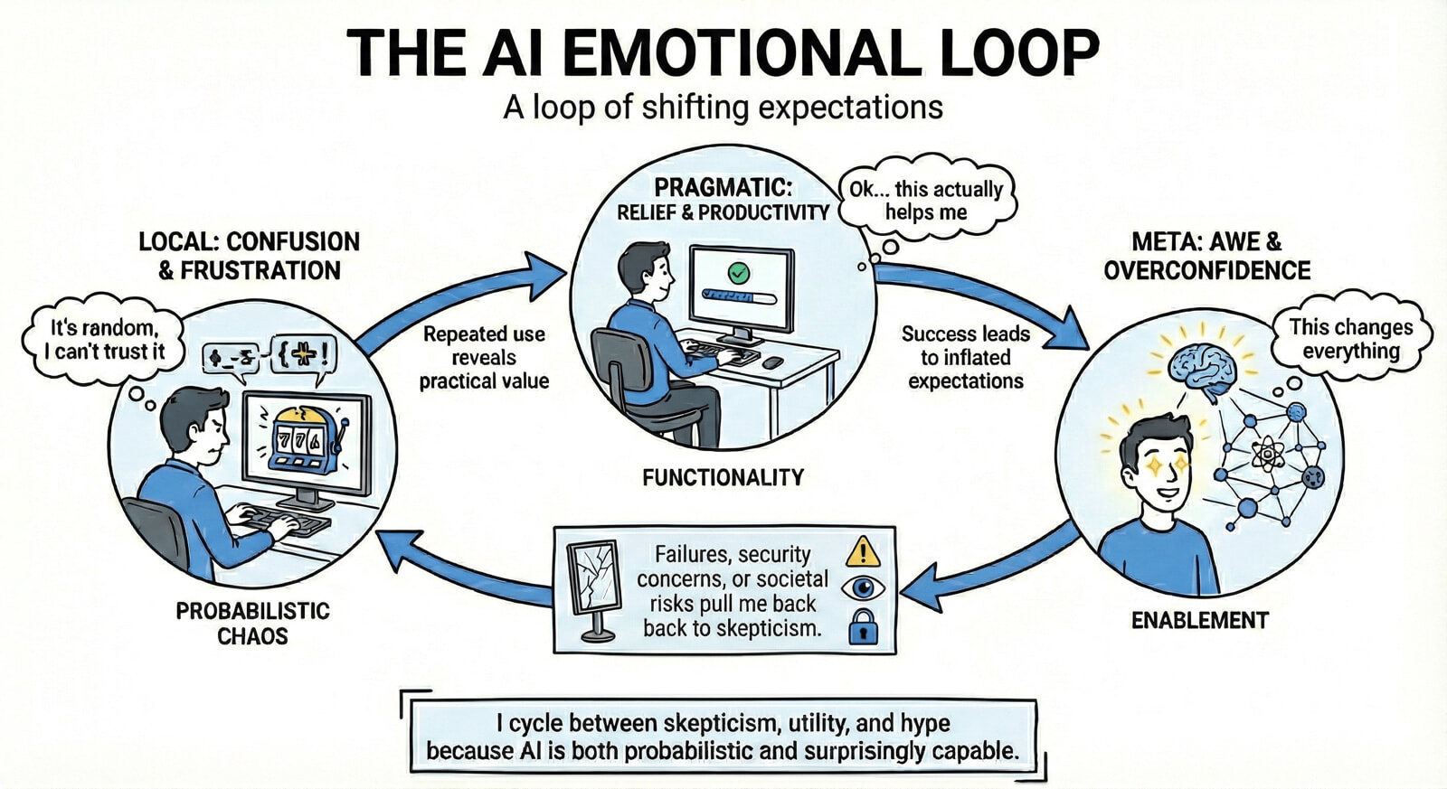
My perspective about AI swings between slot-machine chaos, mind-blown optimism, and Black Mirror dread. I turned that back-and-forth into an infographic about living in this emotional loop.
Topoprint now supports creating relief maps as RoundRects (rounded rectangles) alongside traditional disc shapes. Backend optimizations have accelerated 3D model processing significantly: a model that once took up to 10 minutes now completes in less than three minutes, complete with a progress bar update to keep users informed. Additionally, the Topodisc Designer web app has been revamped for...
Finding the right balance between Running-the-business (RTB) and Changing-the-business (CTB) can be challenging. This post explains that if RTB tasks are kept to a minimum, Scrum can be effective. However, if those tasks increase, adopting a hybrid or Kanban system can significantly help maintain smooth workflows and achieve operational excellence.

This blog post outlines the process of creating multi-color 3D prints using the Bambu Lab X1 Carbon printer and the Topoprint software. I explain how to prepare multiple STL files for distinct landscape features, using OrcaSlicer for effective slicing. The final print, requiring extensive filament changes, showcases the Landwasserviadukt.

Last week, Switzerland’s Birchgletscher collapsed and caused a major rock avalanches, altering the landscape and burying the village of Blatten. With the data of the federal Rapid Mapping service and the help of individual experts, a first open post-event elevation model was made available. I used the model to create pre- and post-event visualizations and prints at a local scale.

Topoprint has introduced three significant updates to its service for creating 3D mini-reliefs, or Topodiscs, of Swiss locations: bridges with arches, an easy-to-use Topodisc designer and an automated printing-as-a-service option.

The post explores an SQL query using DuckDB and OvertureMaps data to extract, filter, and visualize pizza places in Switzerland. All these steps can be done in one line, and the generated map of Swiss pizza places can be viewed immediately using PMTiles.

This article describes "star-collector," a tool for automatically publishing web favorites using GitHub Actions and AI-generated titles, leveraging transformers for title creation from Mastodon posts.

Introducing Topoprint.ch, a platform for creating personalized, 3D-printable topographic models of any location in Switzerland, accessible through social media bots. This post explains the "what," the "why," and a bit of the "how.".
